GATE CE · Geomatics Engineering
Generate GATE-level questions on Remote Sensing Gis Gps And Photogrammetry in Geomatics Engineering. Focus on core concepts, previous year patterns, and numerical problem-solving techniques.
13 questions · 13 PYQs · 0 AI practice · GATE CE 2027
🎯 These are sample questions
Just sign in to unlock everything. Free for all students.
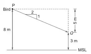
A bird is resting on a point at a height of above the Mean Sea Level (MSL). Upon hearing a loud noise, the bird flies parallel to the ground surface and reaches a point which is located at a height of above MSL. The ground surface has a falling gradient of 1 in 2. Ignoring the effects of curvature and refraction, the horizontal distance (in meters) between points and is ____ (in integer).
For a reconnaissance survey, it is necessary to obtain vertical aerial photographs of a terrain at an average scale of 1:13000 using a camera. If the permissible flying height is assumed as 3000m above a datum and the average terrain elevation is 1050 m above the datum, the required focal length (in ) of the camera is
If the size of the ground area is and the corresponding photo size in the aerial photograph is , then the scale of the photograph is 1 : ____ (in integer).
An aerial photograph is taken from a flight at a height of 3.5 km above mean sea level, using a camera of focal length 152 mm. If the average ground elevation is 460 m above mean sea level, then the scale of the photograph is
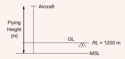
A camera with a focal length of 20 cm fitted in an aircraft is used for taking vertical aerial photographs of a terrain. The average elevation of the terrain is 1200 m above mean sea level (MSL). What is the height above MSL at which an aircraft must fly in order to get the aerial photographs at a scale of 1:8000?
A square area (on the surface of the earth) with side 100 m and uniform height, appears as 1 on a vertical aerial photograph. The topographic map shows that a contour of 650 m passes through the area. If focal length of the camera lens is 150 mm, the height from which the aerial photograph was taken, is
An aerial photograph of a terrain having an average elevation of 1400 m is taken at a scale of 1:7500. The focal length of the camera is 15 cm. The altitude of the flight above mean sea level (in m, up to one decimal place) is ______
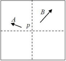
Two towers A and B, standing vertically on a horizontal ground, appear in a vertical aerial photograph as shown in the figure. The length of the image of the tower A on the photograph is1.5 cm and of the tower B is 2.0 cm. The distance of the top the tower A (as shown by the arrowhead) is 4.0 cm and the distance of the top of the tower B is 6.0 cm, as measured form the principal point p of the photograph. If the height of the tower B is 80 m, the height (in meters) of the tower A is_____

The number of spectral bands in the Enhanced Thematic Mapper sensor on the remote sensing satellite Landsat-7 is
Optimal flight planning for a photogrammetric survey should be carried out considering
The system that uses the Sun as a source of electromagnetic energy and records the naturally radiated and reflected energy from the object is called
The minimum number of satellites needed for a GPS to determine its position precisely is
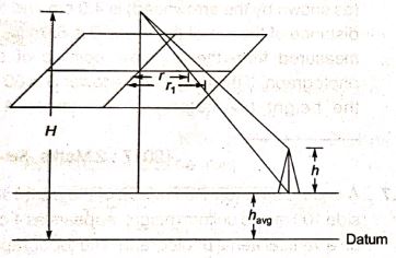
A tall tower was photographed from an elevation of 700 m above the datum. The radial distances of the top and bottom of the tower from the principal points are 112.50 mm and 82.40 mm, respectively. If the bottom of the tower is at an elevation 250 m above the datum, then the height (expressed in m) of the tower is _____.
Want unlimited AI-generated Remote Sensing Gis Gps And Photogrammetry questions?
Sign up free and practice with adaptive difficulty — Easy, Medium, Hard. New questions every session.
Start practising for free →