GATE CE · Geomatics Engineering
Generate GATE-level questions on Fundamental Concepts Of Surveying in Geomatics Engineering. Focus on core concepts, previous year patterns, and numerical problem-solving techniques.
14 questions · 14 PYQs · 0 AI practice · GATE CE 2027
🎯 These are sample questions
Just sign in to unlock everything. Free for all students.
A surveyor measured the distance between two points on the plan drawn to a scale of and the result was 468 m. Later, it was discovered that the scale used was . The true distance between the points (in m) is ______ (round off to the nearest integer).
What is the CORRECT match between the survey instruments/parts of instruements shown in the table and the operations carried out with them?
A student is scanning his 10 inch 10 inch certificate at 600 dots per inch (dpi) to convert it to raster. What is the percentage reduction in number of pixels if the same certificate is scanned at 300 dpi?
The magnetic bearing of the sun for a location at noon is . If the sun is exactly on the geographic meridian at noon, the magnetic declination of the location is ___
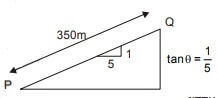
A line between stations P and Q laid on a slope of 1 in 5 was measured as 350 m using a 50 m tape. The tape is known to be short by 0.1 m. The corrected horizontal length (in m) of the line PQ will be
The error in measuring the radius of a 5 cm circular rod was 0.2%. If the cross-sectional area of the rod was calculated using this measurement, then the resulting absolute percentage error in the computed area is______. (round off to two decimal places)
In general, the CORRECT sequence of surveying operations is
Which of the following is/are correct statement(s)?
In a survey work, three independent angle, X, Y and Z were observed with weight respectively. The weight of the sum of angles X, Y and Z is given by:
Which of the following statements is FALSE?
The survey carried out to delineate natural features,such as hills, rivers, forests and manmade features, suchas towns, villages, buildings, roads, transmission lines and canals is classified as
The plan of a survey plotted to a scale of 10 m to 1 cm is reduced in such a way that a line originally 10 cm long now measures 9 cm. The area of the reduced plan is measured as 81 . The actual area ( ) of the survey is
The type of surveying in which the curvature of the earth is taken into account is called
The plan of a map was photo copied to a reduced size such that a line originally 100 mm, measures 90 mm. The original scale of the plan was 1:1000. The revised scale is
Want unlimited AI-generated Fundamental Concepts Of Surveying questions?
Sign up free and practice with adaptive difficulty — Easy, Medium, Hard. New questions every session.
Start practising for free →